"I'm going to build my secrets into the Geometry of these buildings, because I know that books can be burned but buildings not so easily."
- Thomas Jefferson
The Newport Tower Story
by Arthur D. Faram
Introduction
Updated 7/21/2017
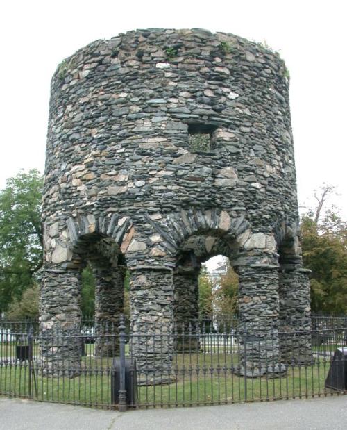
The Newport Tower has been the subject of discussion and controversy since the Colonists first arrived in the new world and discovered the structure on Rhode Island, USA. Early explorers noted that
the tower existed during their early explorations of North America. However, that did not deter skeptics from claiming that the tower was constructed in Colonial times. Documented research shows that
the tower was most likely constructed in the 15th Century, destroyed in the 16th Century and then rebuilt in the 17th Century on the 200th anniversary of its original construction. The Newport Tower is
an important North American Landmark; however, it is the Newport Island itself that has been an important focal point of civilizations around the world for thousands of years.
Geoglyphology
The information gathered for presentation on this website was gathered using the new science of Geoglyphology. (Google keyword: Geoglyphology). The calculations performed on both this website and
the Kensington Runestone website require the use of a special software called "Google Earth". Google's software is able to calculate true spherical bearings on a curved surface and then display them
correctly on a flat plane. In the following photos the true curvature of the lines is missing. For simplicity the great circle line was established and then only the endpoints were connected. This software can
be acquired free by searching the internet using the keywords "Google Earth".
Spherical Geometry
In spherical geometry all lines are curved along the surface and no lines are parallel. It is difficult to grasp the concept that two parallel headings can cross. That is because we are used to thinking in terms
of Plane Geometry on a flat plane. However, this changes when you draw lines on a sphere. In dealing with a sphere you enter the realm of Spherical Geometry.
Spherical Geometry is the study of figures on the surface of a sphere, as opposed to the type of geometry studied in plane geometry or solid geometry. In spherical geometry, straight lines are great circles,
so any two lines will meet in two places. There are also no parallel lines. The angle between two lines in spherical geometry is the angle between the planes of the corresponding great circles, and a spherical
triangle is defined by its three angles. There is no concept of similar triangles in plane geometry.
In the field of Geoglyphology, we are plotting lines in a spherical world and then displaying the results on a flat plane. It is difficult to grasp the concept of combining Spherical Geometry with Plane Geometry.
That is why the field of Geoglyphology could not have been proposed without the advent of software that computes using Spherical Geometry and then displays it on a flat plane. This type of precise mapping
precludes the plotting of these bearings on a flat map. Maps become distorted when converted from a sphere to a flat map. Any lines that are depicted on a flat non-satellite map, on this website, were first
plotted using the Google software and then drawn on the flat map after the end points were determined. Even then, the proper curvature is missing.
The Newport Tower
The Newport Tower has been carbon dated as being over 500 years old. The simple geometry associated with the Tower is outlined below. The results of the carbon dating and details of the Newport Tower,
the Kensington Runestone, and many more landmarks, geoglyphs and monoliths can be found in the book "Ancient Signposts". The book can be found on Amazon.com. As you will
see below, the Newport Tower and Inspiration Peak Locations have been known and revered for thousands of years.
Purpose
Newport Tower was built by early inhabitants of North America for two reasons. The first was to point the way to Inspiration Peak, a place of special geographical importance. The second was to substantiate
the builders land claim to North America by using the unique geographical location of Newport (RI USA) and Inspiration Peak, MN. The predecessors of the people that built the tower knew of Newport, RI
USA for over 7000 years. This is substantiated by the Egyptian Gulfo de Centra geoglyph in West Africa that points out the Newport Tower site. There was a reason that North America held some special
significance. Geoglyphs found around the world show that people were mapping out what would later be known as the United States as far back as the building of the Mayan Pyramids. Mayan Pyramids
located in Central America outline the boundaries of what would eventually become the United States. (Ref: The book "Ancient Signposts - 2011)
An Ancient Egyptian Geoglyph That Identified the Future Newport Tower Site 7000 years before the tower was built.
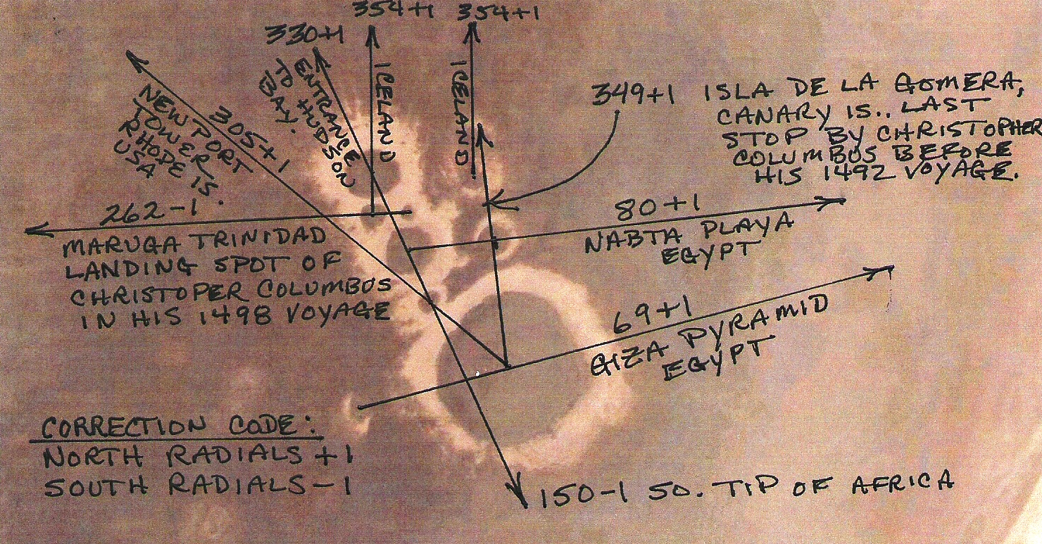
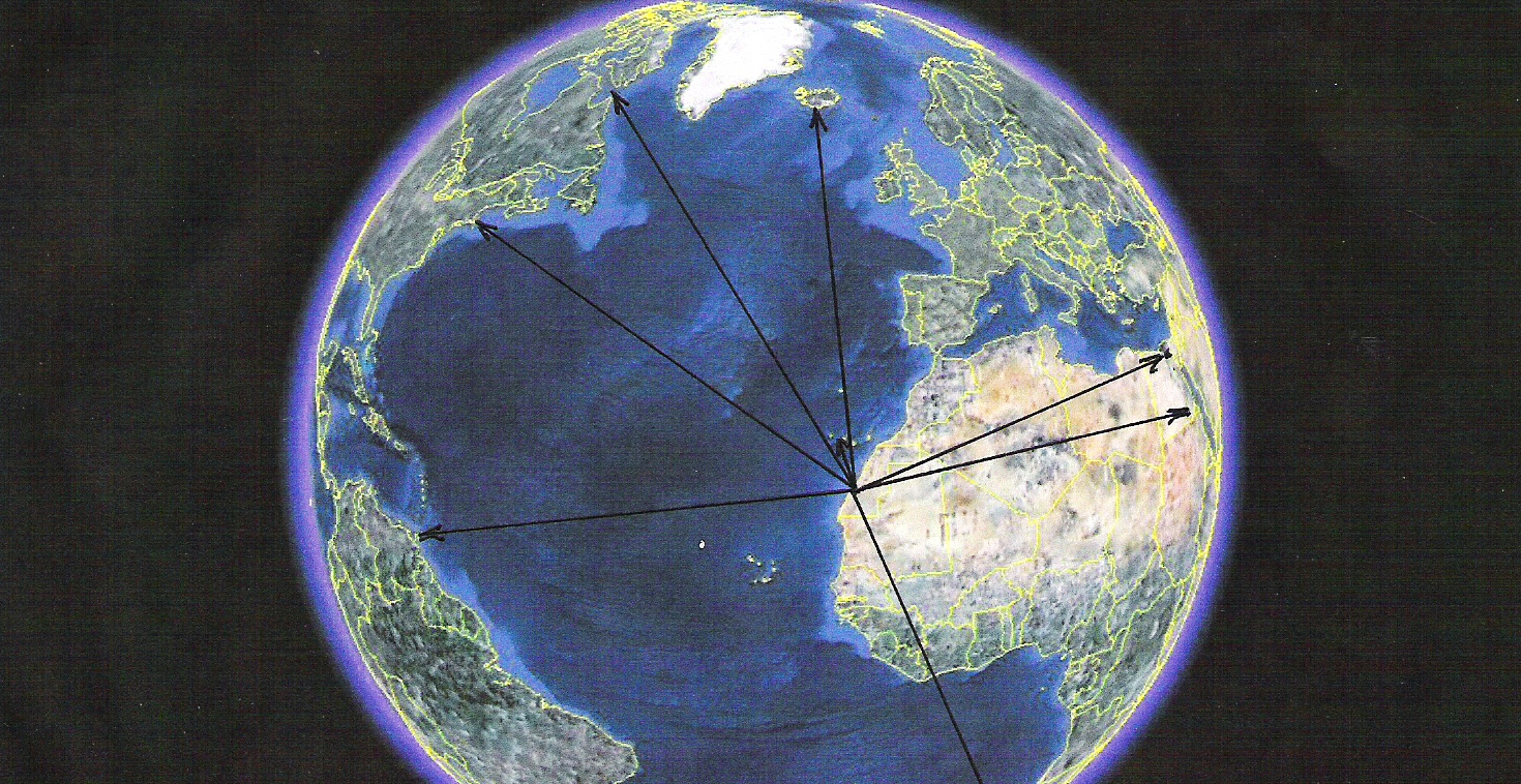
The 7000 Year Old Gulfo de Cintra Glyphs, Western Sahara, Africa (23* 01' 32.58"N - 16* 07' 04.69"W)
The Gulfo de Cintra Glyph, Radial End Points
The Gulfo de Cintra geoglyphs are some of the most spectacular that we have encountered in all our investigations around the world. First of all they are very clear. There is no doubt where the centers of
the defining circles are. This is due to the fact that they consist of stone slabs sitting atop 30 foot high towers of sand. This the result of 7000 years of wind blowing the sand from around them and the slabs
compacting the sand. Secondly, all the resulting radials point to well established markers which have been used many times by cultures around the world. This leaves no doubt as to where they were intended to
point. The Gulfo de Cintra Glyphs were discovered by Arthur Faram in 2009 by following the directions from the 7000 year old Egyptian geoglyph, called Nabta Playa. Nabta Playa has been identified and
accurately dated by accredited archeologists.
It is obvious that ancient civilizations were able to understand things that we are just beginning to understand. If you will remember, in your history studies, the Hebrews were involved in the engineering
and oversight of the building of the pyramids. Did the Egyptians, Hebrews, Greeks, Celts, and early Christians have some knowledge that others did not have; the knowledge to build the Pyramids, knowledge
to build Stonehenge, knowledge of the geography of the entire world? The geoglyphs located around the world indicate that the answer is yes.
Newport (RI) in Antiquity
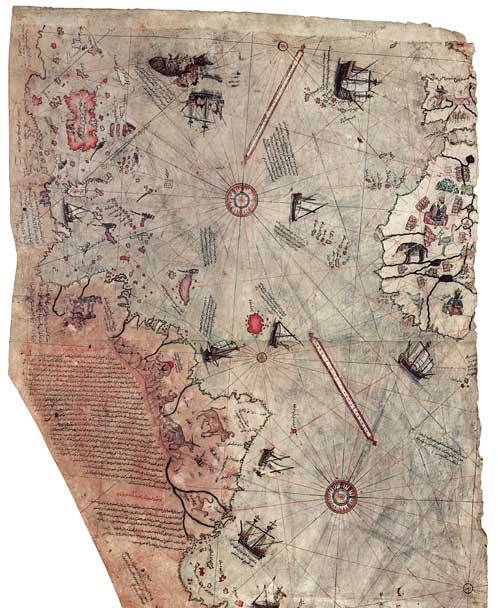
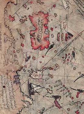
The 1513 Piri Reis Map
This is the left fragment of the Piri Reis map showing Central and South American shores. The Piri Reis map is a pre-modern world map compiled in 1513 from military intelligence by the Ottoman-Turkish
admiral and cartographer Piri Reis. The half of the map that survives shows the western coasts of Europe and North Africa and the coast of Brazil with reasonable accuracy. Various Atlantic islands are
depicted including the Azores, Canary, Cape Verde and the Antilles. The historical importance of the map lies in its demonstration of the extent of exploration of the New World by 1513. It used 10 Arabian
sources, 4 Indian maps, all sourced from the Portuguese, and only one map from Columbus.
Section of the Piri Reis Map Depicting the East Coast of North America
This section of the map is presented to verify that Newport (RI) was a settlement long before the Voyage of Columbus in 1492. In the Piri Reis Map a brown symbol that looks very much like a castle
(or towers) is depicted where Newport would be. If you will notice it is the only evidence of a settlement anwhere on the coast of North or South America. This would seem to validate the antiquity of
that location. As you can see, in the previous map, similar brown symbols representing settlements are located on the map in Western Africa. Incidentaly, the lines you see on the maps are radials
projected from ancient geoglyphs. If no one had been to North America why would there be radials originating there?
To orientate yourself to this map notice the following: (All locations are referred to by their current names.)
01. The white island at the top is Iceland.
02. The red island at the top is Greenland.
03. The indentation of the shoreline west of Greenland is the Saint Lawrence Seaway.
04. The white island below Greenland is the same shape as Newfoundland. (Though obviously misplaced.)
05. The petrusion to the left of Newfoundland is Nova Scotia.
06. The curved Coast below Nova Scotia is the coast of Maine, New Hampshire and Massachusetts.
07. The petrusion on the bottom of the Castle is Cape Cod.
08. The Castle symbol is Newport, RI.
09. The peninsula below the ship is Florida.
10. The water below Florida is the Gulf of Mexico.
11. The long line of islands to the East of Florida is the Netherland Antilles.
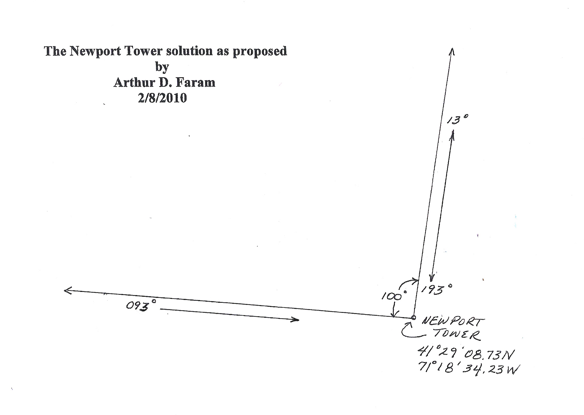
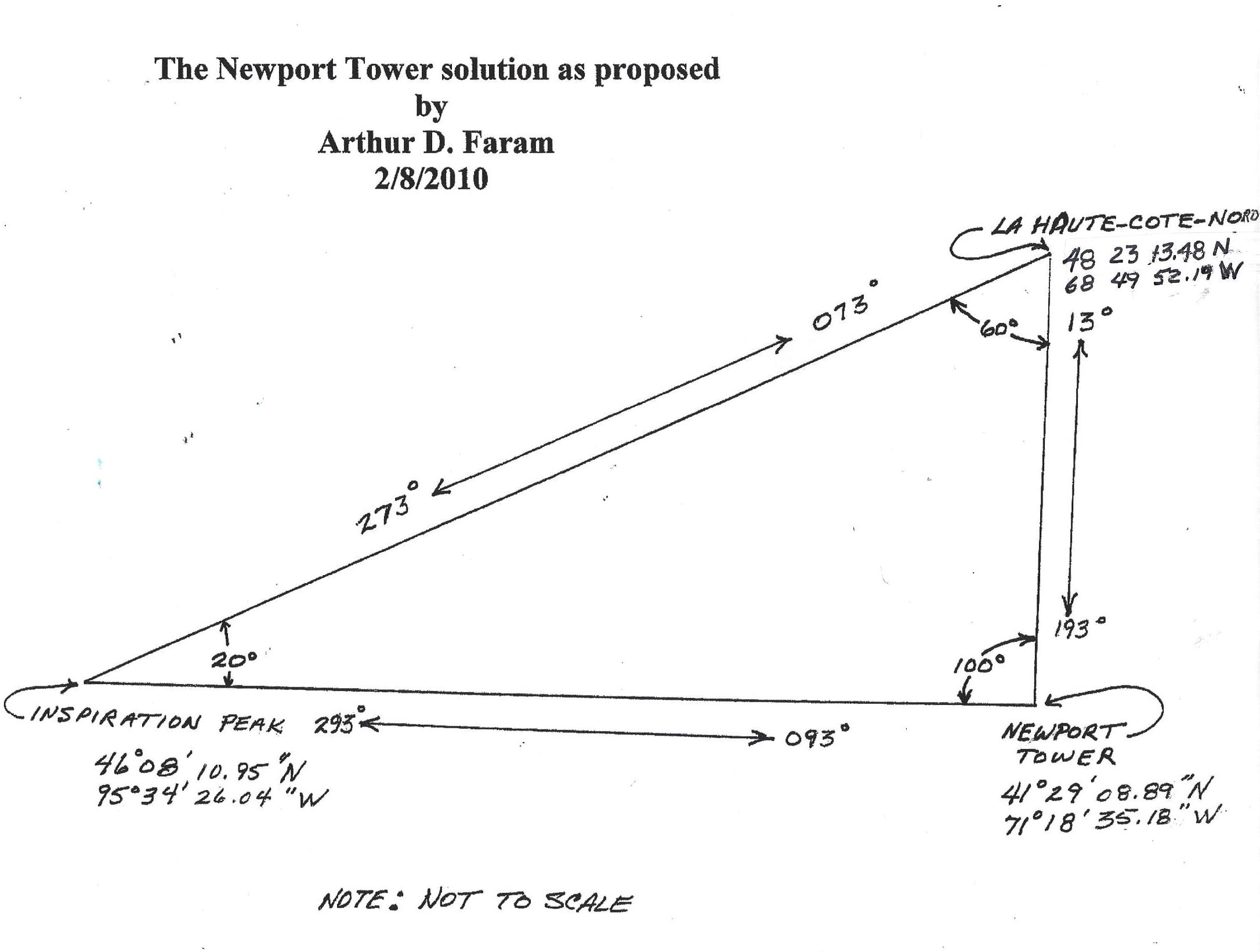
The Geometry of the Newport Tower Mystery
The Newport 013 Radial
Something that must be remembered about the builders of the tower is that they place little value on words. The builders, their predecessors and descendents, are men of
numbers and symbols. You should also know that the builders, and their predecessors, never present a puzzle without setting up another solution to the same puzzle by some
other method. This prevents the skepticism that has prevailed over the past centuries about the Newport Tower and other ancient artifacts which no verification from another
source has been found, until now. It is a known fact that the Newport Tower is aligned along a 93/273 degree axis. In addition there has always been a question as to why most
European structures, of non-secular origin, have six legs while this one has eight legs. It was decided that the eight legs might be a clue.
Was it possible that the eight legs on the tower were a symbol for 80 degrees. Navigators of this era oriented their maps and alignments to the East. As a result the solution
was started by subtracting 80 degrees from the East orientation of 93 degrees. This obviously left a bearing of 13 degrees. If this was correct there now existed one angle, and two
sides of undefined length, to a triangle. In order for the 13 degree radial to be significant a geographical location along the 13 degree bearing would have to be found to define the
length of that side of the triangle.
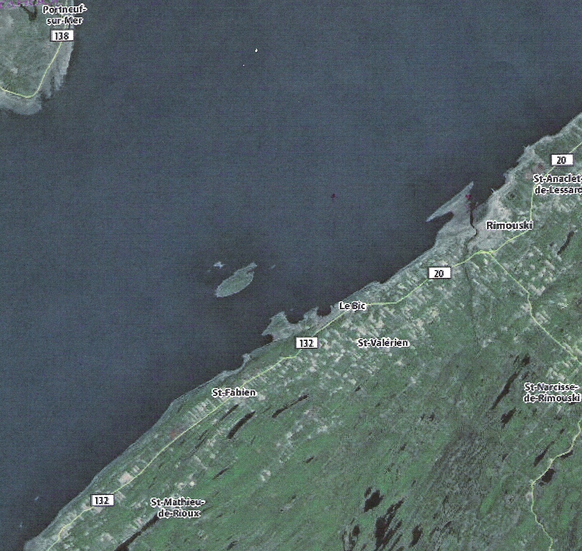
La Haute-Cote-Nord (48 23 53.32N 68 52 04.17W)
While tracing along the 13 degree bearing it was noticed that the line went directly over a small island in the Saint Lawrence Seaway named "La Haute-Cote-Nord". La Haute-Cote
-Nord in French, loosely translated, means "The Highest Point on the North Dimension". This appeared to be a vital clue. If so there now existed two sides, one length and one angle of the triangle.
In order to make a triangle one more angle or length was needed. During previous research several other triangles were discovered. The angles of the information collected thusfar at Newport coincided with an
angle in the previously identified triangles. It was decided to apply those angles to the Newport triangle to see if there was any significance to the previously identified information. Sure enough there was a
corolation. It was as if the other triangles were constructed to give the solution to the Newport mystery.
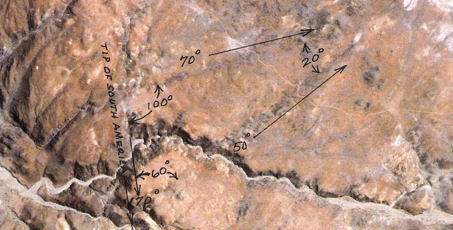
The Capiapo Chile Triangle
This triangle is located in Capiapo, Chili and is just one of the many glyphs scattered around the globe as clues to substantiate the Newport Triangle solution. The importance of this triangle is that it provides
the three angles that make up the Newport Triangle. This was just one more check to substantiate that the solution to the Newport Triangle is valid. This and other pertainent geoglyphs, pertaining to the
Newport Tower, were discoverd by following the directions provided by geoglyphs all over the world. This in itself proves the validity of Geoglyphology.
The Capiopo triangle consists of three interior angles of 20, 60 and 100 degrees. Since 100 degrees was the one angle that had already been decoded from the Newport Tower it
was decided to apply the other two angles to the partially completed triangle to see what developed. The sides of the triangle were extended to the West because to the East there was nothing but water.
If a significant landmark existed at the point of the western vertex a solution to the mystery of the Newport Tower may have been found. As hoped, there was a significant landmark situated right under the
Western vertex of the triangle. The name of that landmark is Inspiration Peak, this triangle was named the Newport Triangle. The resulting triangle is in the next image.
The Newport Triangle
As hoped, there was a significant landmark situated right under the western vertex of the triangle. The name of that landmark is Inspiration Peak. A diagram of the resulting Newport Triangle appears above.
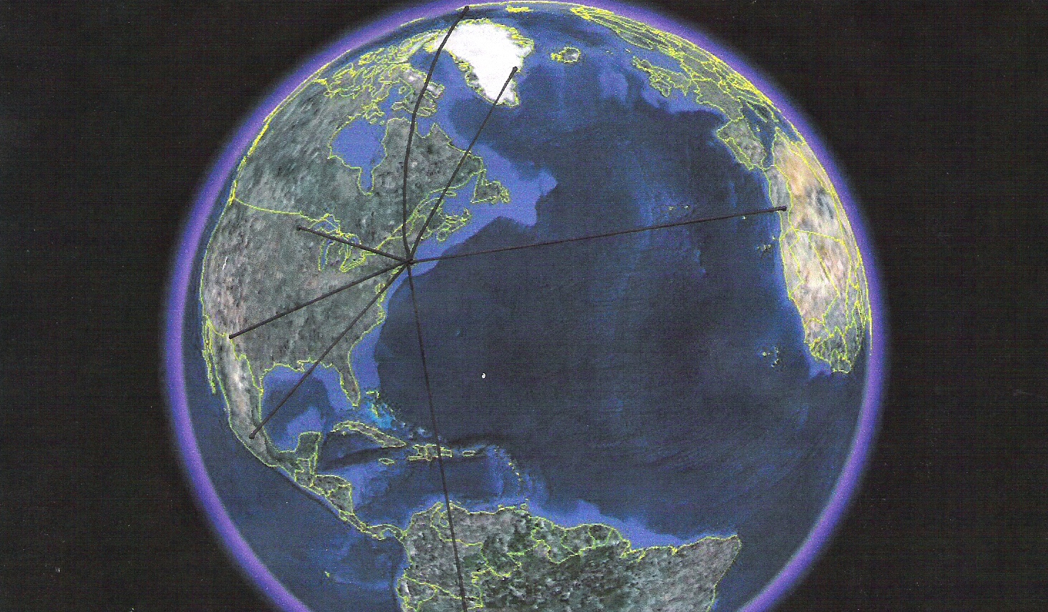
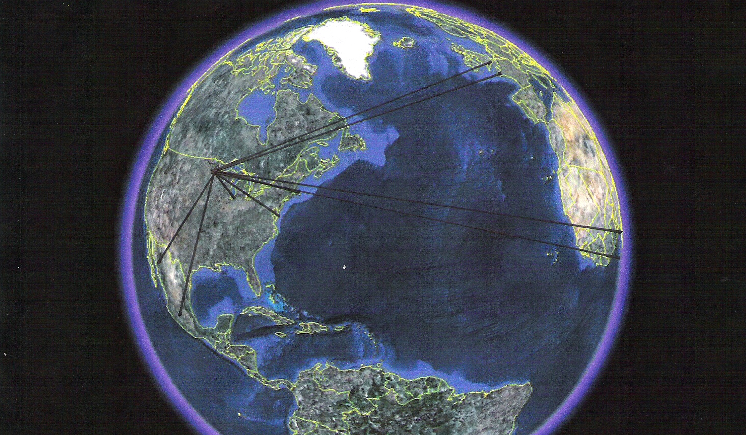
Photo showing known origination points of geoglyphs, around the world which point to the Newport Tower Location
Origination points for the pointers displayed in the above photo. Included are the approximate dates the pointers were created.
Gulfo de Cintra Geoglyphs, Sahara West Africa - c7000BC
Inspiration Peak, Minnesota USA - c7000BC - 3100BC
Cahuachi, Nazca Peru - c5AD
Pyramids of China - c100BC - 400AD
Tiniteqilaq Geoglyph, Greenland - c1100AD
River Geoglyph El Paso, Texas USA - c1300
Mexico City Geoglyph - c1325AD
Kensington Runestone, Minnesota USA - c1473AD
"Michoacan", Mexico, Mural Glyph by Diego Rivera - c1925
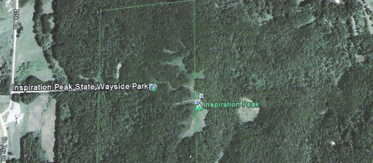
Inspiration Peak
Inspiration Peak, Minnesota USA (46 08 09.49N 95 34 14.61W)
Inspiration Peak, like the Newport Tower location, has been known and surveyed for thousands of years. The knowledge of the significance of Inspiration Peak in ancient times is identified and verified by
Stonehenge in England. The dating of Stonehenge has already been established as circa 3100 BC by celebrated scientists and archeologists around the world and should not present fuel for controversy.
Inspiration Peak was not only identified by the complex mathematics built into the Newport Tower, but is also identified by many other geoglyphs around the world, including Stonehenge. This also holds true
for the site where the Newport Tower resides.
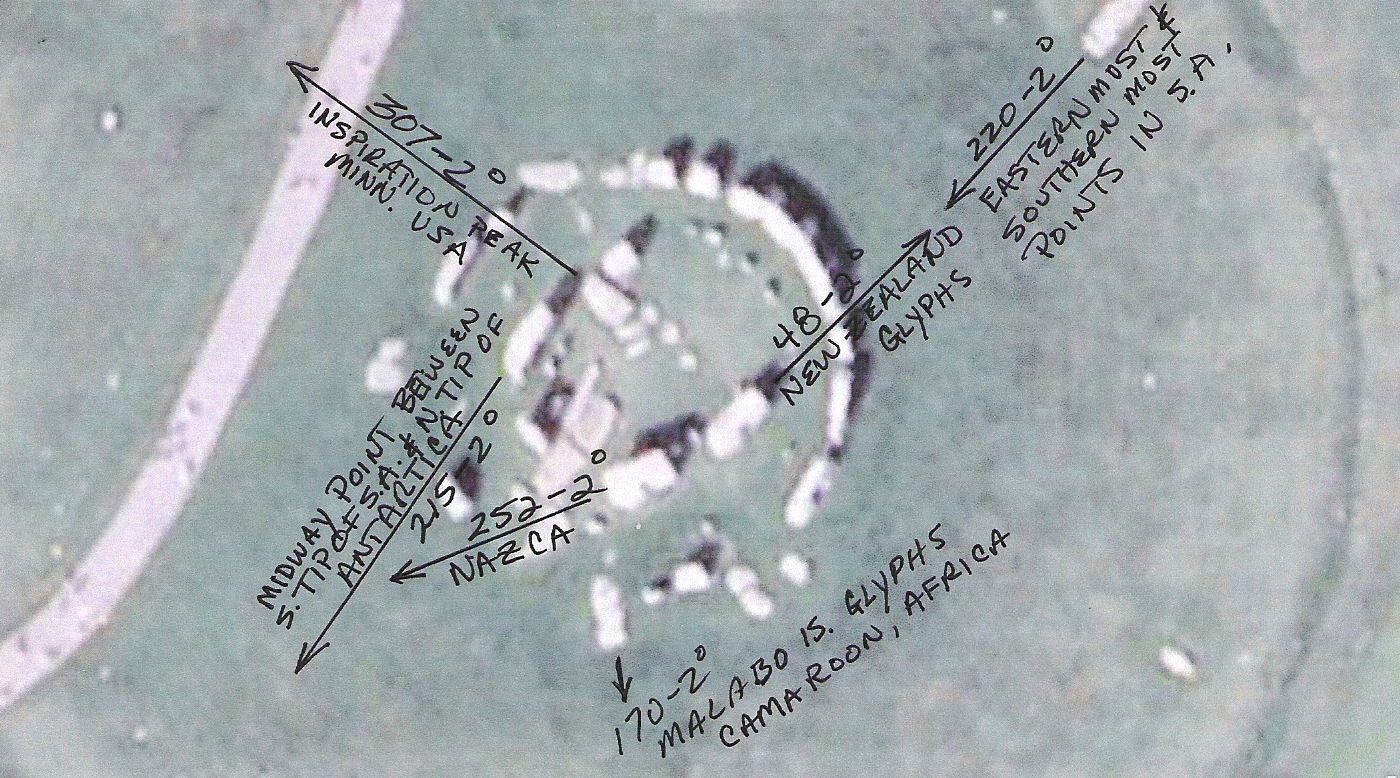
Radials generated by the Stonehenge geoglyph, one of which is Inspirition Peak, MN.
Photo showing known origination points of geoglyphs that point to the Inspiration Peak Location
Origination points for the pointers displayed in the above photo. Included are the approximate dates the pointers were created.
Stonehenge Monolith, UK - c3100BC
Monte Alban Pyramid, Oaxaca Mexico - c500BC
Pigeon Point Geoglyph, Minnesota USA - c1200AD
Manchester, Ohio Geoglyph USA - c1300AD
Kensington Runestone, Minnesota USA - c1362AD
23rd Street NW Geoglyph, Washington DC USA - c1400AD
Point du Raz Geoglyphs, Bretagne, France - c1400AD
Malabo Island Geoglyphs, Equatorial New Guinea, West Africa - c1400AD
Cape of Good Hope Geoglyphs, South Tip of Africa - c1400AD
Atanacio Geoglyphs, Mexico - c1400AD
Newport Tower, Newport, RI USA - c1473AD
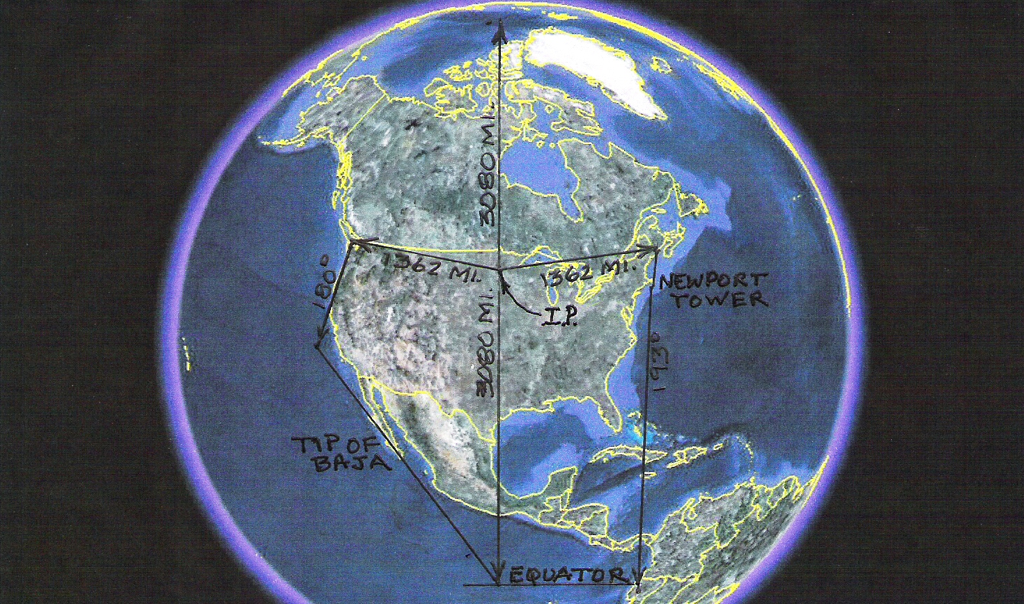
Inspiration Peak, Minnesota USA - The North American Territory Deeded to the Templars by the Portuguese c1362 CE.
(Notice that Inspiration Peak is the Geographic center of this territroy.)
Inspiration Peak lies halfway between the Equator and the North Pole. The Peak lies 1362 miles from ancient NW, NE and southern geoglyphs which had an influence on the final boundaries of the
United States. More details can be found on Amazon.com in a book titled "Ancient Signposts". For ancient cultures to be able to locate and survey this location, and tie it
to the Newport Tower location, over 7000 years ago boggles the mind. The Newport Tower and Kensington Runestone (Link provided below to the Kensington Runestone website.) are the most important
of the markers which have been found in North America. They are important because these two markers are able to combine together to delineate the North American land claim as it existed when Stonehenge
was built and as it existed after it was modified following the Spanish invasion of Mexico.
Inspiration Peak, USA - Revised North American Territory c 1362 - 1519 CE
Using the geoglyphic data retrieved from the Kensington Runestone, Newport Tower and Inspirition Peak a picture of the revised North American (US) Territory was made possible..
. The Kensington Runestone was not needed until this revision presented itself. This is the territory agreed to between the Templars, Portugal and Spain sometime between their
allience in ridding the Iberian Peninsula of the Moors and the invasion of Mexico, by Hernando Cortez, in 1519 CE. Before the invasion of Mexico the Templars, later to become
the Masons, owned the territory shown in the image previous to this one. That was the territory that was relinquished to the Templars for aiding Portugal and Spain rid the Iberian
Peninsula of the Moors.
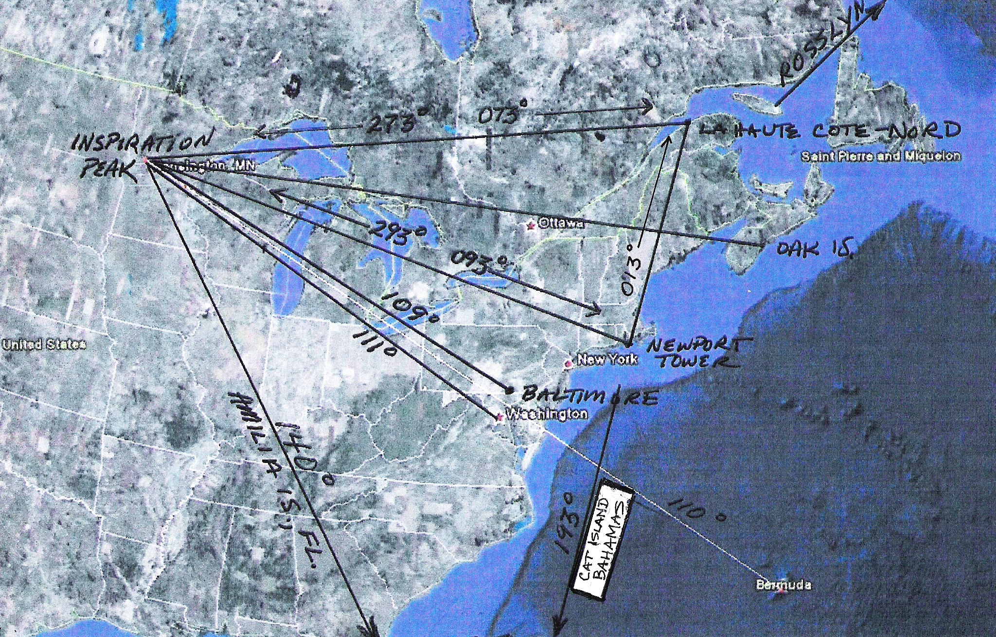
Inspiration Peak Radials as defined by the Kensington Runestone.
In the previous image all the bearings associated with solving of the Newport Tower and the Kensington Runestone mysteries are depicted. The 013 degree bearing was the initial
bearing that had to be discovered before the puzzles could be solved. The reciprocal of the 013 degree bearing is the 193 degree bearing which will become important in defining
the claim to North America. In the solving of the puzzle the magnetic bearings of 073 and 273 degrees became known. (See above) They are not reciprocal headings because they
originate from two different points on the earths surface and are affected by magnetic deviation. In the decoding of the Kensington Runestone, which verified the math in the
Newport Tower solution, the bearings of 110 and 140 were also mentioned. Note that the 111 radial, which usually represents the Trinity, goes through the current capitol of the
USA. This could not have been a coincidence.
It is from the data in the previous Plate, drawn out on a map similar to the one that follows, from which, in 1362 the early colonizers of North America staked their final claim to
what turned out to be the United States.
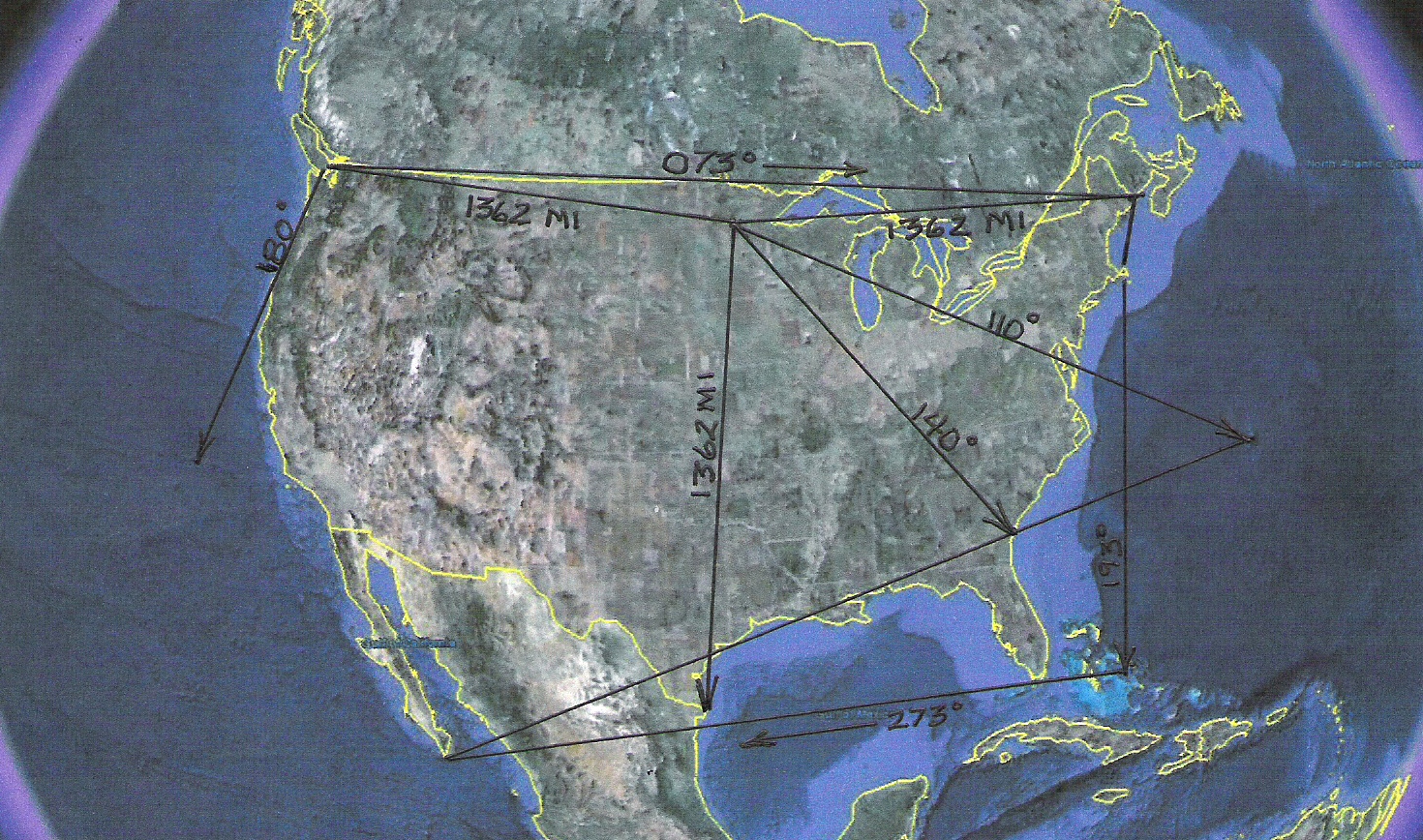
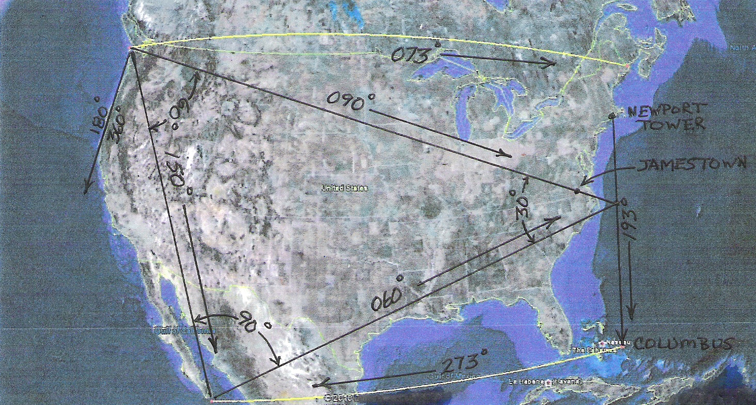
Map of the North America Land Claim and the Great Triangle
This diagram points out the land claim devised by the early inhabitants of North America in 1362. The claim is bounded on the East by the 013/193 degree radial that runs through the Newport Tower to Cat
island in the Bahamas, on the South by the 273 degree radial which runs West from where the 193 degree radial intersects Cat Island in the Bahamas, and the 073 degree radial which runs from the Northwest
corner of the US to the Northeast corner of the US.
The Western limits are defined by the 360/180 degree radial. If you will notice, the 193, 273 and 073 degree radials are all duplicated in the Newport Triangle
solution. Just another cross check devised by the early inhabitants of North America. The Southwest corner of the claim, that is the tip of Baja California, is additionally defined by running a line between the
termination points of the 140 degree radial and the 110 degree radial mentioned on the Kensington Runestone. The termination point for the 110 degree radial is Bermuda. The termination point for the
140 degree radial is the point where the 140 degree bearing crosses the East Coast (Amelia Island). By running a line between the Bahamas termination point and the Amelia Island termination point the line
ends precisely at the tip of Baja California. This is just another cross check which the originators included to prove to the interpreter that they were on the right track.
Now, if a line is drawn between the Northwest corners of the claim to the Southwest corner of the claim a line running on a 150 degree heading is created. If a 90 degree vertex is added to the Southwest end
of the line and a 60 degree vertex is added to the Northwest end of the line a perfect 30/60/90 Right Triangle is created. As if this were not enough the 30/60/90 triangle terminates on the 193 degree radial from
the Newport Tower. This type of triangle is considered the perfect triangle, and an icon, by the ancients.
It is no coincidence that the SE corner of this land claim was where Columbus landed on his first voyage. It is clear that Spain was attempting to establish a land claim to the Culf of Mexico and Mesoamerica.
This is proved out by the Geoglyphs found several Carribean islands which were left by Columbus to claim the land for Spain. The original boundary between, what is now the US and Canada was established
by the building of the Stonehenge geoglyph c3100 BC.
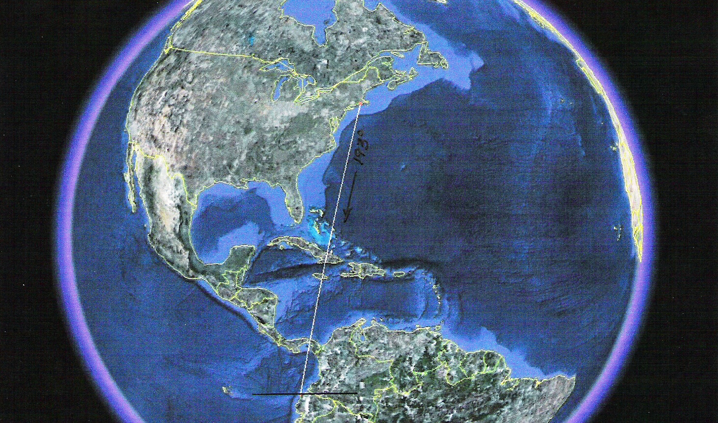
The Newport Tower 193 Degree Radial
Further confirmation that the 013/193 Degree Radial was not chosen at random is the fact that when extended to the South it intersects exactly at where the Equator crosses the coast of Ecuador. This point
has been confirmed as an important marker to the ancients and is identified by numerous glyphs around the world. As you have seen previously, the 193 radial runs through Cat Island, previously named
San Salvedor, and terminates at the intersection of the Equator and the west coast of South America. These points were the landing spot of Christopher Columbus on his first voyage and the southern tip
of the Templar territory, as deeded by Portugal.
The combinations of mathematics, geometry, and survey skills necessary to accomplish such a perfect geometrical puzzle are phenomenal. By including two of the same bearings
used in the solution of the Newport Triangle the originators are not only showing their skill but as usual providing a crosscheck to verify to any investigator that they have the
correct solution to the land claim. As stated before the early colonizers of America always provide a way of verifying their work. By the time you finish reading the Kensington Runestone solution
(linked below) you should be convinced that the Kensington Runestone, the Newport Tower and Inspiration Peak all compliment and verify the credibility of each other. It is obvious that the evidence
shows a time consuming survey of North America. A prudent person would have to question who did it, when did they do it, and why. The answers are astonishing, but not surprising.
To see the relationship between the Kensington Runestone and the Newport Tower,
Click Here
This information is copyrighted but may be copied for educational, editorial, broadcast, and non-commercial
use only. The originating author's name and a link to this website must appear in the article.
 Click here for Amazon.com in the US
 Click here for Amazon.com in the UK